- Home
- Resources
- Work samples
- Samples
- Global poverty map analysis – AT
Humanities and Social Sciences
Year 6
Satisfactory
Global poverty map analysis
 1
Learning Area
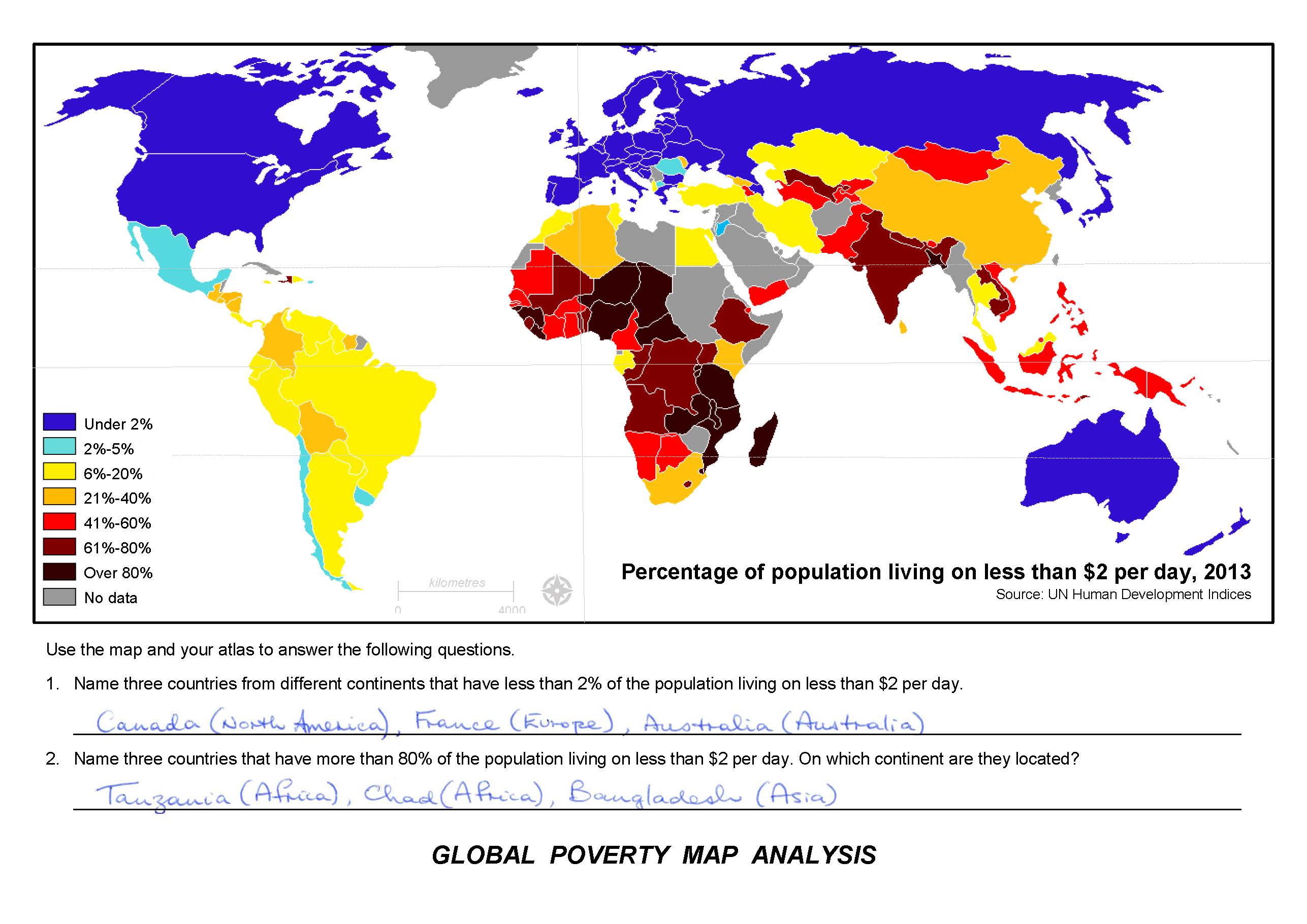
Uses information sources to identify countries 2 Subject - Geography
Uses information sources to identify countries
-
Annotations
-
1
Learning Area
Uses information sources to identify countries -
2
Subject - Geography
Uses information sources to identify countries
 1
Learning Area
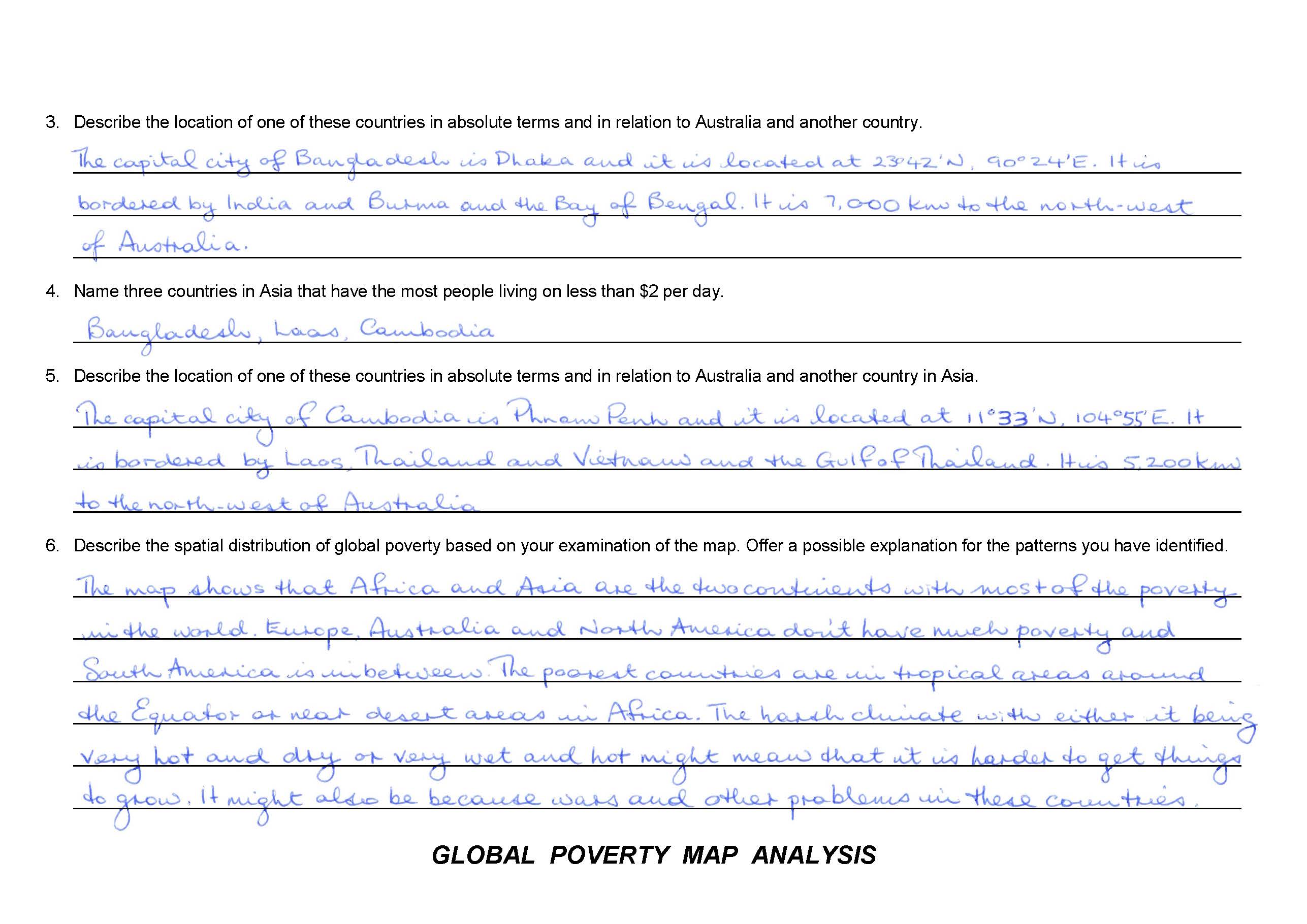
Uses latitude and longitude to locate countries 2 Learning Area
Describes the relative location of countries to Australia 3 Subject - Geography
Uses latitude and longitude to locate countries 4 Subject - Geography
Describes the relative location of countries to Australia 5 Learning Area
Makes generalisations about the global distribution of poverty based on geographical regions 6 Subject - Geography
Makes generalisations about the global distribution of poverty based on geographical regions
-
Annotations
-
1
Learning Area
Uses latitude and longitude to locate countries -
2
Learning Area
Describes the relative location of countries to Australia -
3
Subject - Geography
Uses latitude and longitude to locate countries -
4
Subject - Geography
Describes the relative location of countries to Australia -
5
Learning Area
Makes generalisations about the global distribution of poverty based on geographical regions -
6
Subject - Geography
Makes generalisations about the global distribution of poverty based on geographical regions
Above satisfactory
Global poverty map analysis
 1
Learning Area
Uses information sources to identify countries 2 Subject - Geography
Uses information sources to identify countries
-
Annotations
-
1
Learning Area
Uses information sources to identify countries -
2
Subject - Geography
Uses information sources to identify countries
 1
Learning Area
Uses latitude and longitude to locate cities and countries 2 Learning Area
Describes the relative location and distance between countries and Australia 3 Subject - Geography
Uses latitude and longitude to locate cities and countries 4 Subject - Geography
Describes the relative location and distance between countries and Australia 5 Learning Area
Explains the global distribution of poverty using specific examples 6 Subject - Geography
Explains the global distribution of poverty using specific examples
-
Annotations
-
1
Learning Area
Uses latitude and longitude to locate cities and countries -
2
Learning Area
Describes the relative location and distance between countries and Australia -
3
Subject - Geography
Uses latitude and longitude to locate cities and countries -
4
Subject - Geography
Describes the relative location and distance between countries and Australia -
5
Learning Area
Explains the global distribution of poverty using specific examples -
6
Subject - Geography
Explains the global distribution of poverty using specific examples
Satisfactory
Global poverty map analysis
 1
Learning Area
Uses information sources to identify countries 2 Subject - Geography
Uses information sources to identify countries
-
Annotations
-
1
Learning Area
Uses information sources to identify countries -
2
Subject - Geography
Uses information sources to identify countries
 1
Learning Area
Uses latitude and longitude to locate countries 2 Learning Area
Describes the relative location of countries to Australia 3 Subject - Geography
Uses latitude and longitude to locate countries 4 Subject - Geography
Describes the relative location of countries to Australia 5 Learning Area
Makes generalisations about the global distribution of poverty based on geographical regions 6 Subject - Geography
Makes generalisations about the global distribution of poverty based on geographical regions
-
Annotations
-
1
Learning Area
Uses latitude and longitude to locate countries -
2
Learning Area
Describes the relative location of countries to Australia -
3
Subject - Geography
Uses latitude and longitude to locate countries -
4
Subject - Geography
Describes the relative location of countries to Australia -
5
Learning Area
Makes generalisations about the global distribution of poverty based on geographical regions -
6
Subject - Geography
Makes generalisations about the global distribution of poverty based on geographical regions