- Home
- Resources
- Work samples
- Samples
- Island map – AT
Humanities and Social Sciences
Year 4
Satisfactory
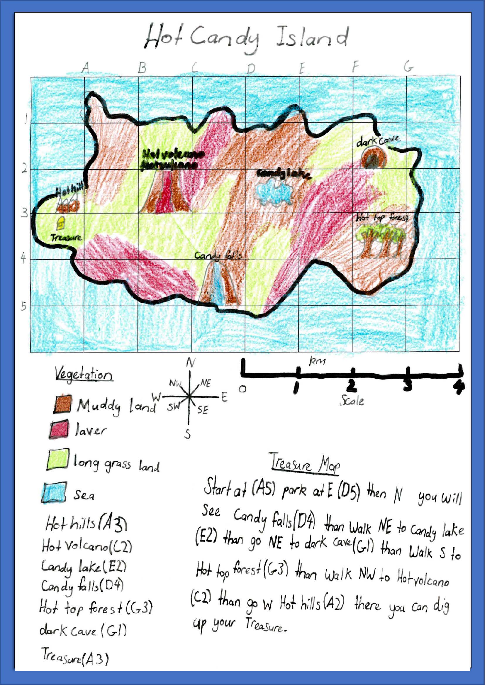
Island map
 1
Learning Area
Draws a map using the cartographic conventions of legend, title, scale and north point 2 Subject - Geography
Draws a map using the cartographic conventions of legend, title, scale and north point 3 Learning Area
Uses grid references and compass directions to give instructions relating to locations on a map 4 Subject - Geography
Uses grid references and compass directions to give instructions relating to locations on a map
-
Annotations
-
1
Learning Area
Draws a map using the cartographic conventions of legend, title, scale and north point -
2
Subject - Geography
Draws a map using the cartographic conventions of legend, title, scale and north point -
3
Learning Area
Uses grid references and compass directions to give instructions relating to locations on a map -
4
Subject - Geography
Uses grid references and compass directions to give instructions relating to locations on a map
Above satisfactory
Island map
 1
Learning Area
Draws a map using the cartographic conventions of legend, title, scale and north point 2 Subject - Geography
Draws a map using the cartographic conventions of legend, title, scale and north point 3 Learning Area
Uses grid references, distance and compass directions to give instructions relating to locations on a map 4 Learning Area
Calculates distance using scale 5 Subject - Geography
Uses grid references, distance and compass directions to give instructions relating to locations on a map 6 Subject - Geography
Calculates distance using scale
-
Annotations
-
1
Learning Area
Draws a map using the cartographic conventions of legend, title, scale and north point -
2
Subject - Geography
Draws a map using the cartographic conventions of legend, title, scale and north point -
3
Learning Area
Uses grid references, distance and compass directions to give instructions relating to locations on a map -
4
Learning Area
Calculates distance using scale -
5
Subject - Geography
Uses grid references, distance and compass directions to give instructions relating to locations on a map -
6
Subject - Geography
Calculates distance using scale
Satisfactory
Island map
 1
Learning Area
Draws a map using the cartographic conventions of legend, title, scale and north point 2 Subject - Geography
Draws a map using the cartographic conventions of legend, title, scale and north point 3 Learning Area
Uses grid references and compass directions to give instructions relating to locations on a map 4 Subject - Geography
Uses grid references and compass directions to give instructions relating to locations on a map
-
Annotations
-
1
Learning Area
Draws a map using the cartographic conventions of legend, title, scale and north point -
2
Subject - Geography
Draws a map using the cartographic conventions of legend, title, scale and north point -
3
Learning Area
Uses grid references and compass directions to give instructions relating to locations on a map -
4
Subject - Geography
Uses grid references and compass directions to give instructions relating to locations on a map