- Home
- Resources
- Work samples
- Samples
- Landforms and landscapes - ABOVE
Geography
Year 8
Above satisfactory
Landforms and landscapes
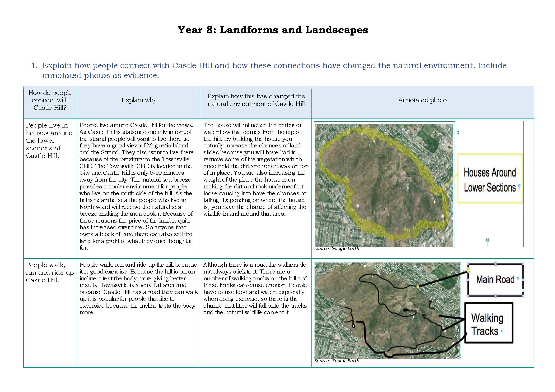 1
Annotation 1
Presents detailed findings in an appropriately formatted table 2 Annotation 2
Explains in detail interconnections between people and places and within environments 3 Annotation 3
Uses relevant geographical terminology and technical vocabulary 4 Annotation 4
Supports findings with a variety of annotated photographic evidence containing specific annotations
-
Annotations
-
1
Annotation 1
Presents detailed findings in an appropriately formatted table -
2
Annotation 2
Explains in detail interconnections between people and places and within environments -
3
Annotation 3
Uses relevant geographical terminology and technical vocabulary -
4
Annotation 4
Supports findings with a variety of annotated photographic evidence containing specific annotations
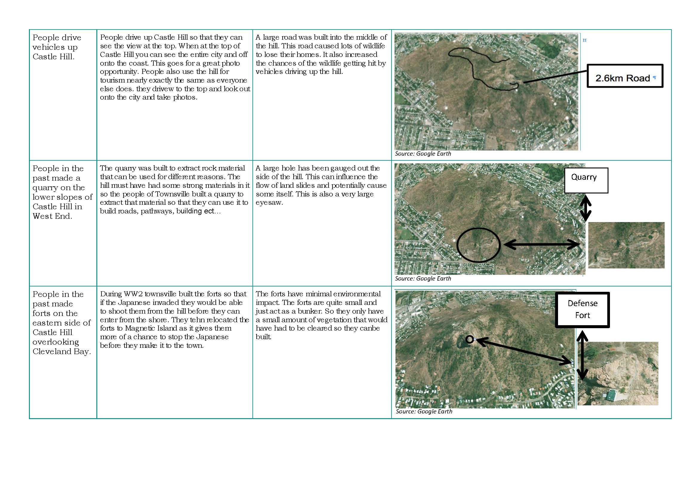 1
Annotation 1
Explains in detail interconnections between people and places and within environments 2 Annotation 2
Uses relevant geographical terminology and technical vocabulary 3 Annotation 3
Supports findings with a variety of annotated photographic evidence containing specific annotations
-
Annotations
-
1
Annotation 1
Explains in detail interconnections between people and places and within environments -
2
Annotation 2
Uses relevant geographical terminology and technical vocabulary -
3
Annotation 3
Supports findings with a variety of annotated photographic evidence containing specific annotations
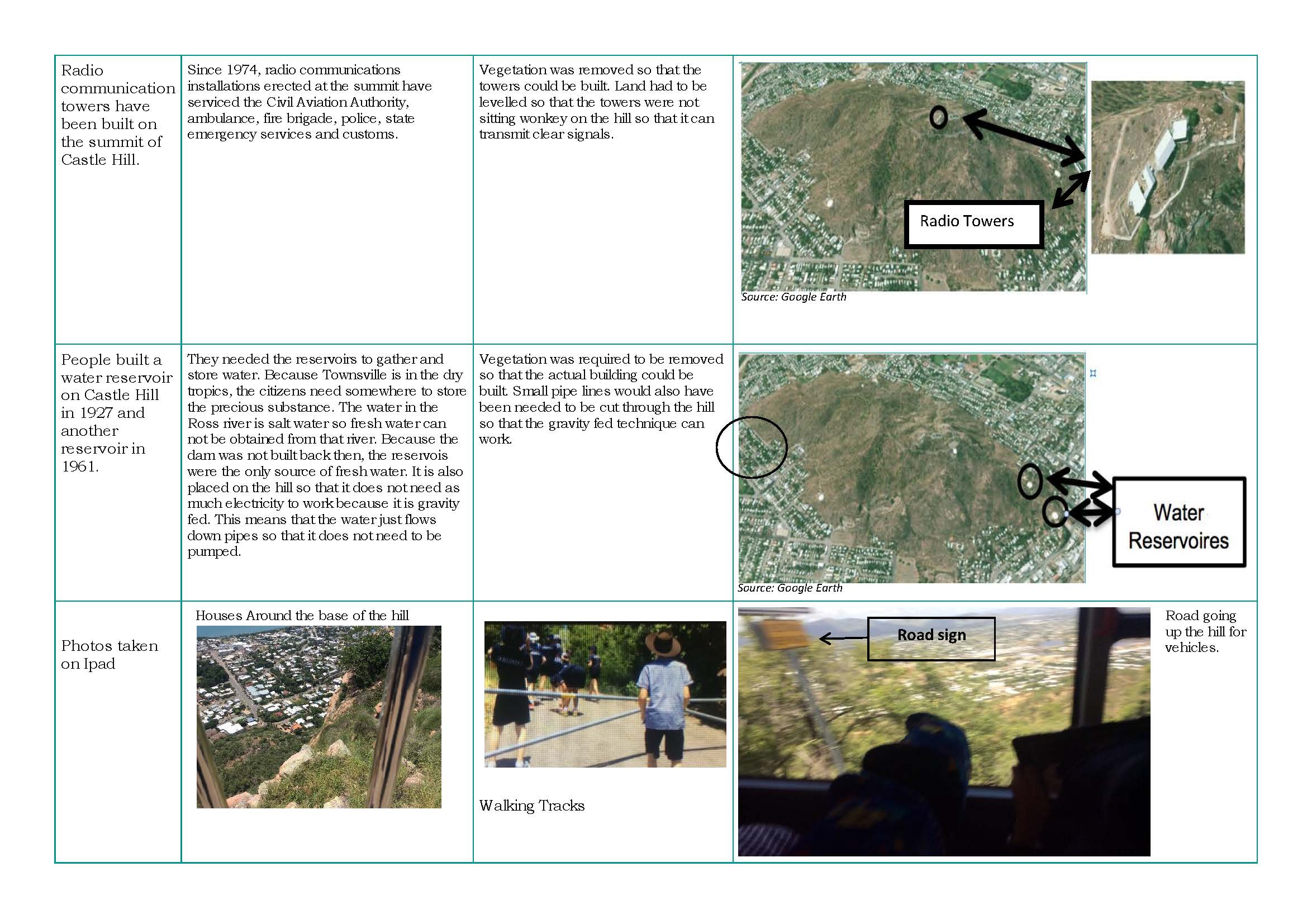
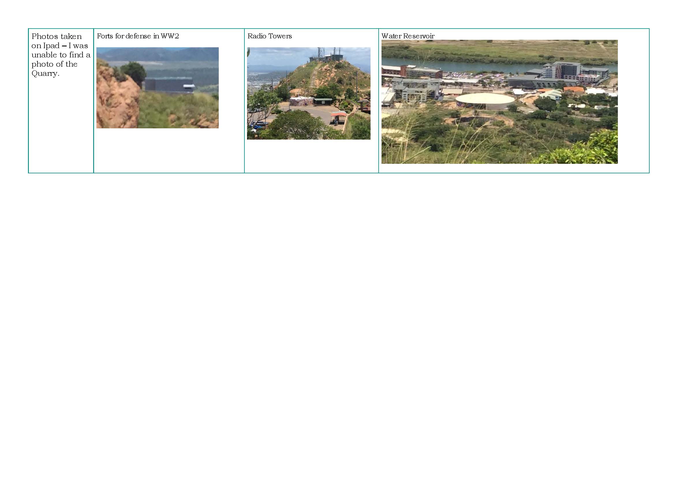 1
Annotation 1
Supports findings with photographic evidence
-
Annotations
-
1
Annotation 1
Supports findings with photographic evidence
 1
Annotation 1
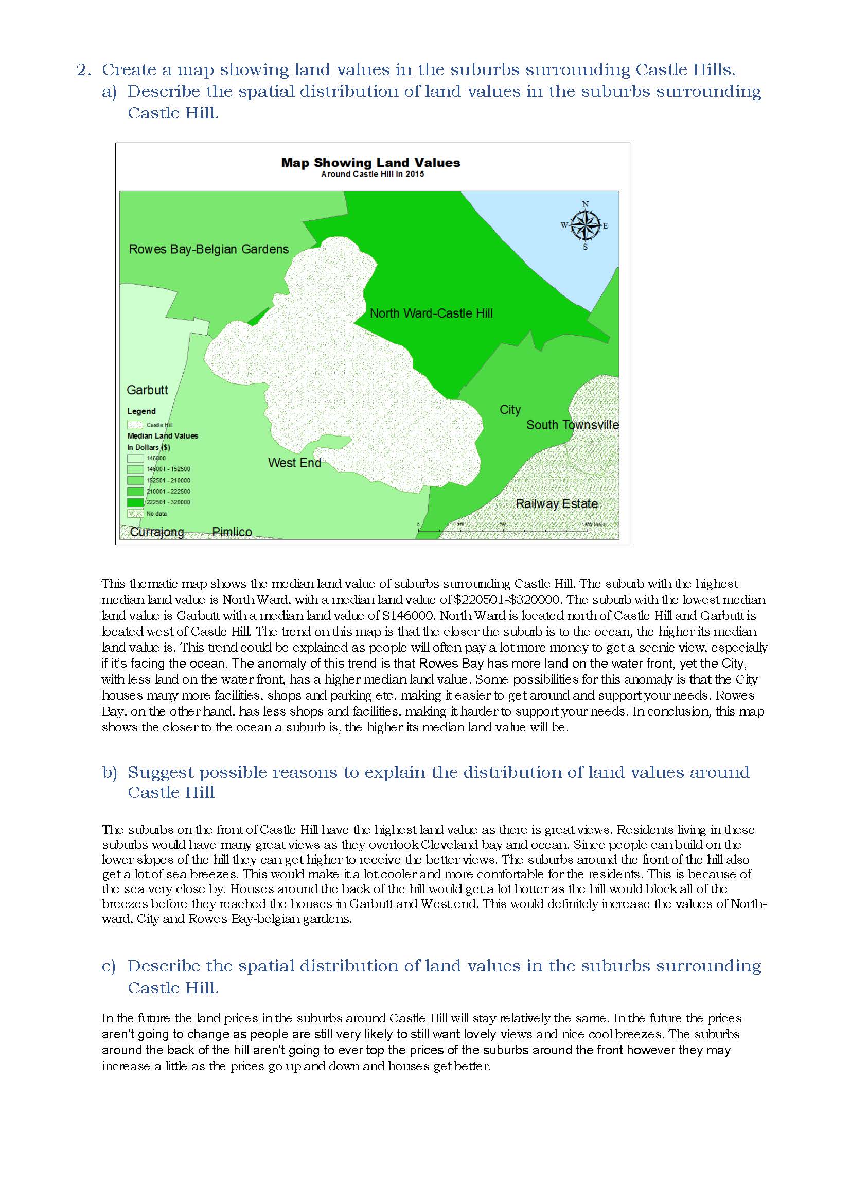
Uses most cartographic conventions 2 Annotation 2
Uses digital technologies to create a map showing land values 3 Annotation 3
Describes in detail the spatial distribution of land values based on the data in the map 4 Annotation 4
Proposes explanations for spatial distributions, patterns and trends 5 Annotation 5
Proposes a detailed explanation for spatial distribution using specific geographical terminology 6 Annotation 6
Proposes changes to future land prices based on spatial distribution, trends and relationships
-
Annotations
-
1
Annotation 1
Uses most cartographic conventions -
2
Annotation 2
Uses digital technologies to create a map showing land values -
3
Annotation 3
Describes in detail the spatial distribution of land values based on the data in the map -
4
Annotation 4
Proposes explanations for spatial distributions, patterns and trends -
5
Annotation 5
Proposes a detailed explanation for spatial distribution using specific geographical terminology -
6
Annotation 6
Proposes changes to future land prices based on spatial distribution, trends and relationships
 1
Annotation 1
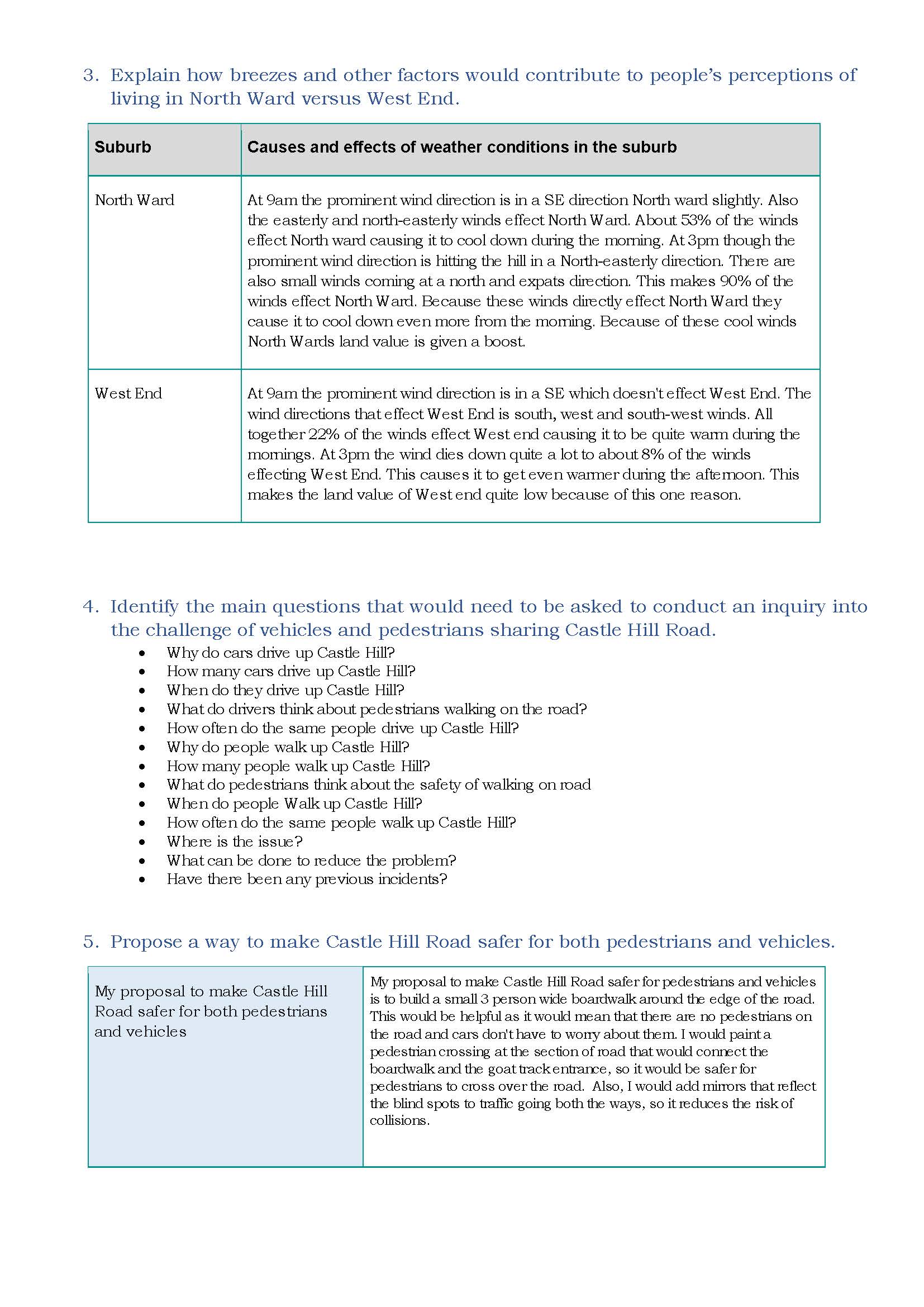
Gives a detailed explanation of the effects of a geographical process on people’s perceptions of living in a place, using data 2 Annotation 2
Proposes insightful, conceptual questions to frame a geographical inquiry 3 Annotation 3
Proposes a detailed set of actions in response to a geographical challenge
-
Annotations
-
1
Annotation 1
Gives a detailed explanation of the effects of a geographical process on people’s perceptions of living in a place, using data -
2
Annotation 2
Proposes insightful, conceptual questions to frame a geographical inquiry -
3
Annotation 3
Proposes a detailed set of actions in response to a geographical challenge
 1
Annotation 1
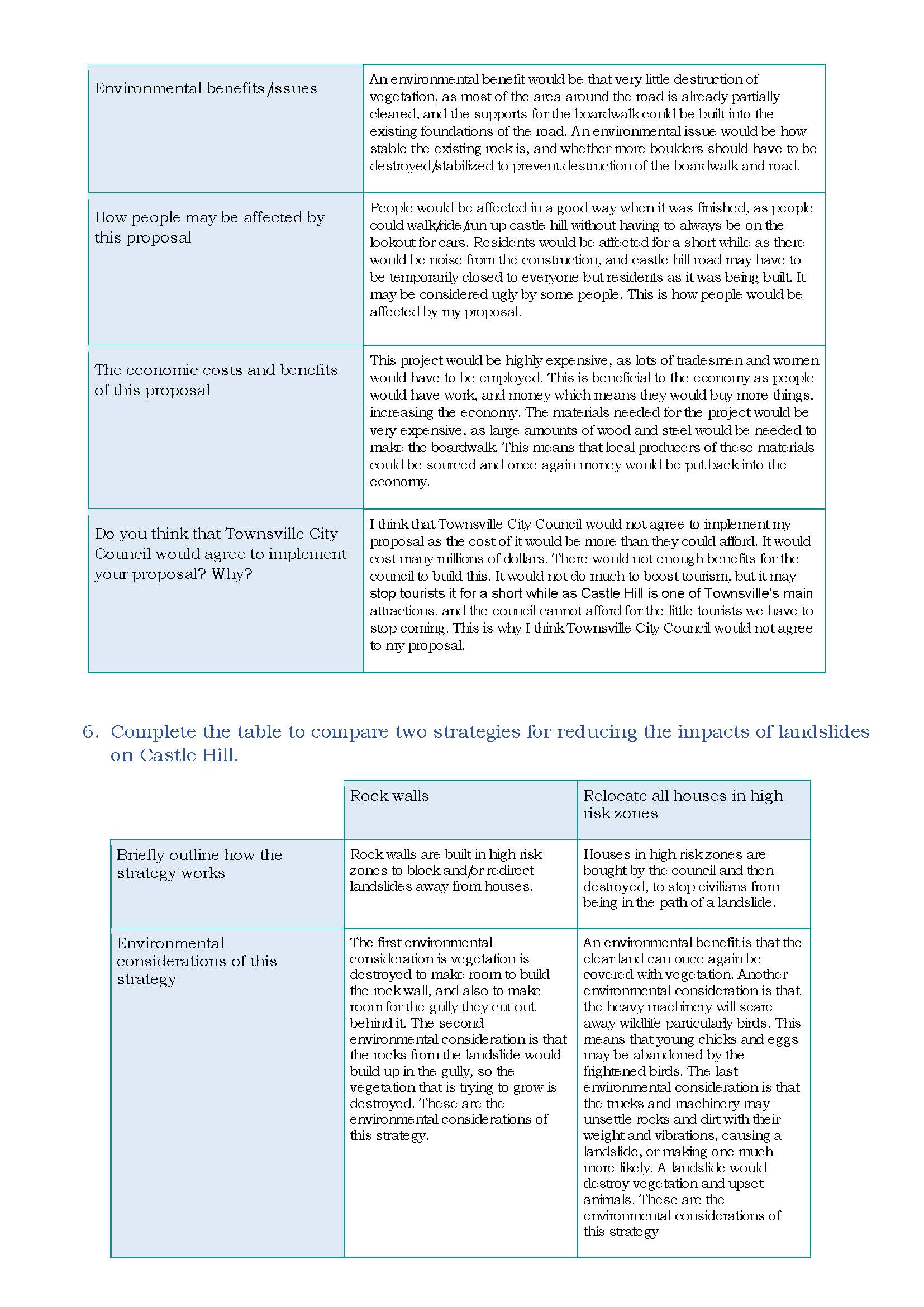
Presents detailed predicted outcomes for each action with supportive reasoning 2 Annotation 2
Uses geographical terminology
-
Annotations
-
1
Annotation 1
Presents detailed predicted outcomes for each action with supportive reasoning -
2
Annotation 2
Uses geographical terminology
 1
Annotation 1
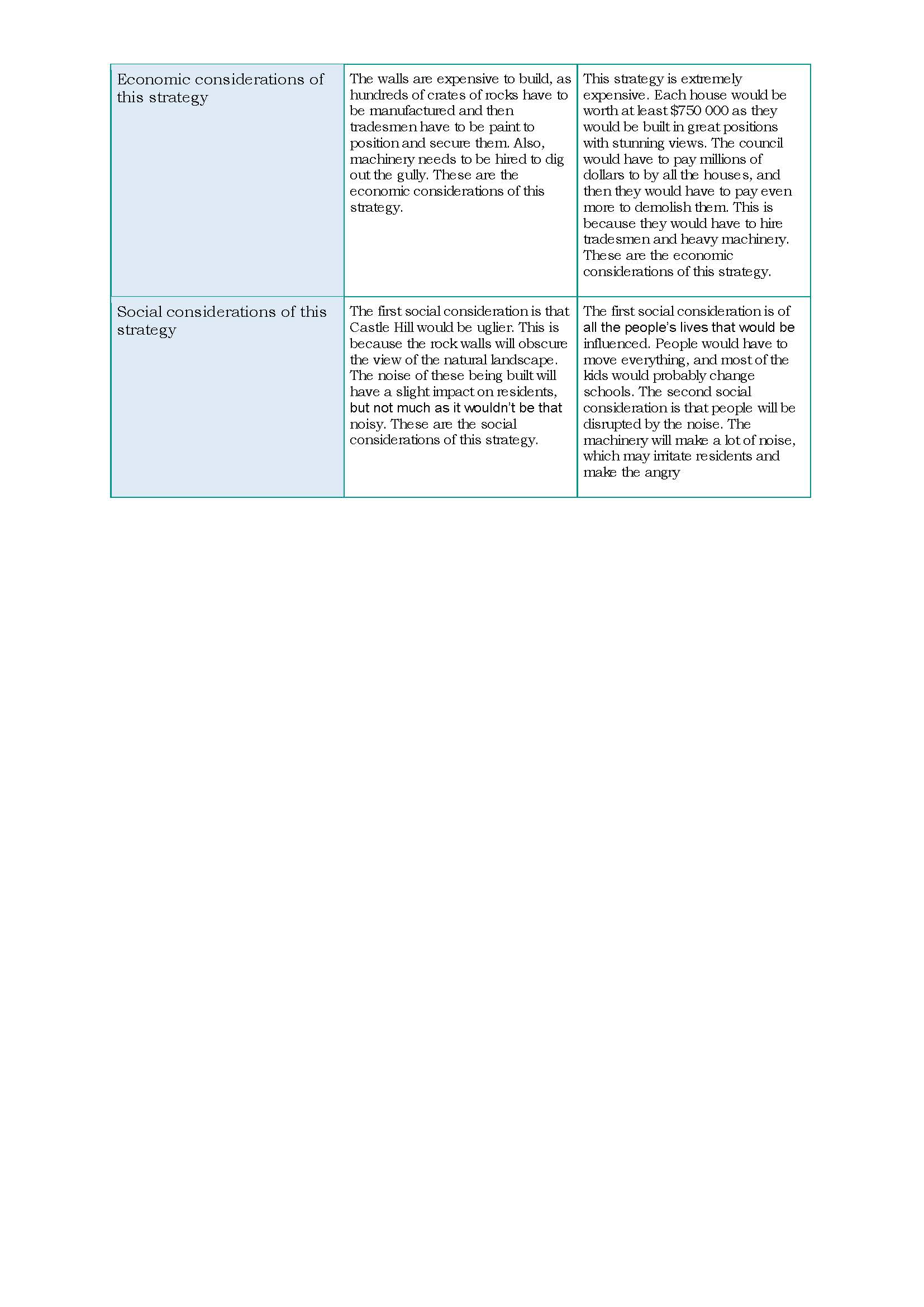
Presents information and analyses the environmental, economic and social impacts of the two strategies, using examples 2 Annotation 2
Uses geographical terminology
-
Annotations
-
1
Annotation 1
Presents information and analyses the environmental, economic and social impacts of the two strategies, using examples -
2
Annotation 2
Uses geographical terminology
Satisfactory
Landforms and landscapes
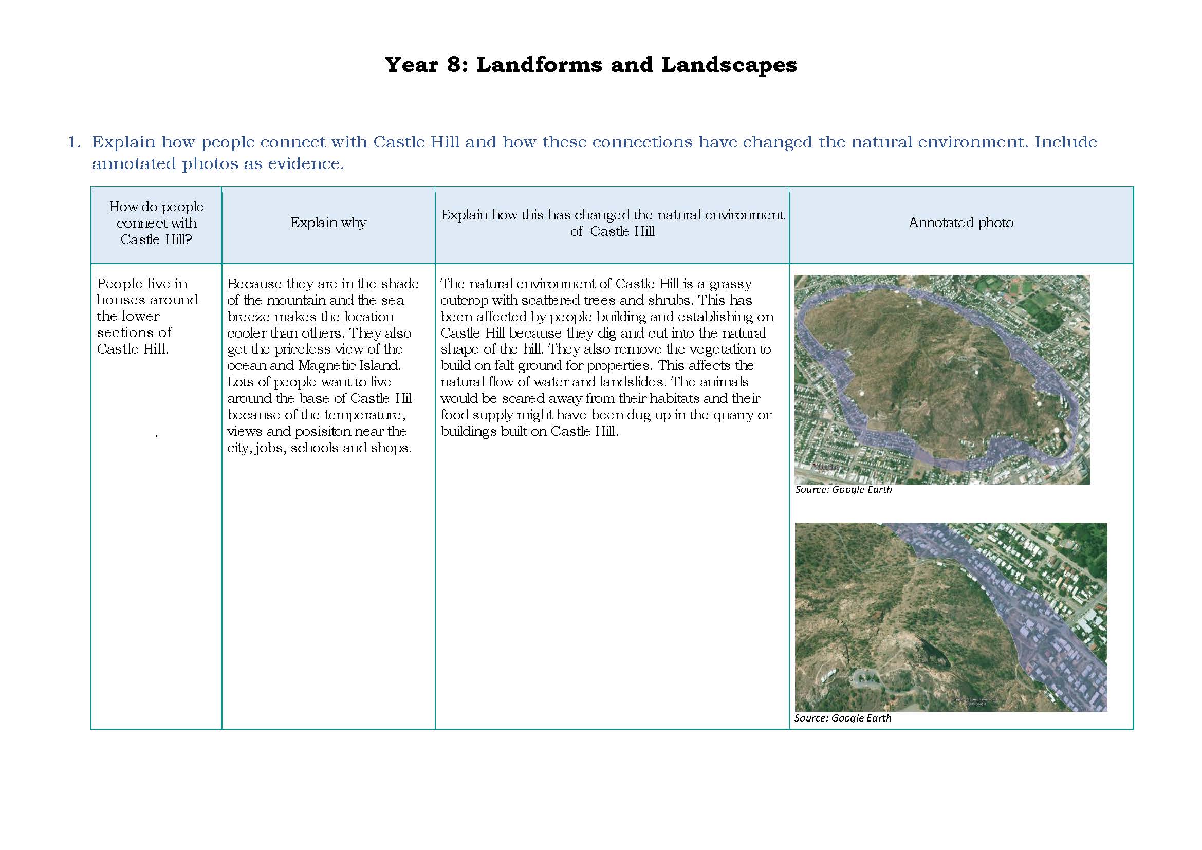 1
Annotation 1
Presents findings in an appropriately formatted table 2 Annotation 2
Explains interconnections between people and places and within environments
-
Annotations
-
1
Annotation 1
Presents findings in an appropriately formatted table -
2
Annotation 2
Explains interconnections between people and places and within environments
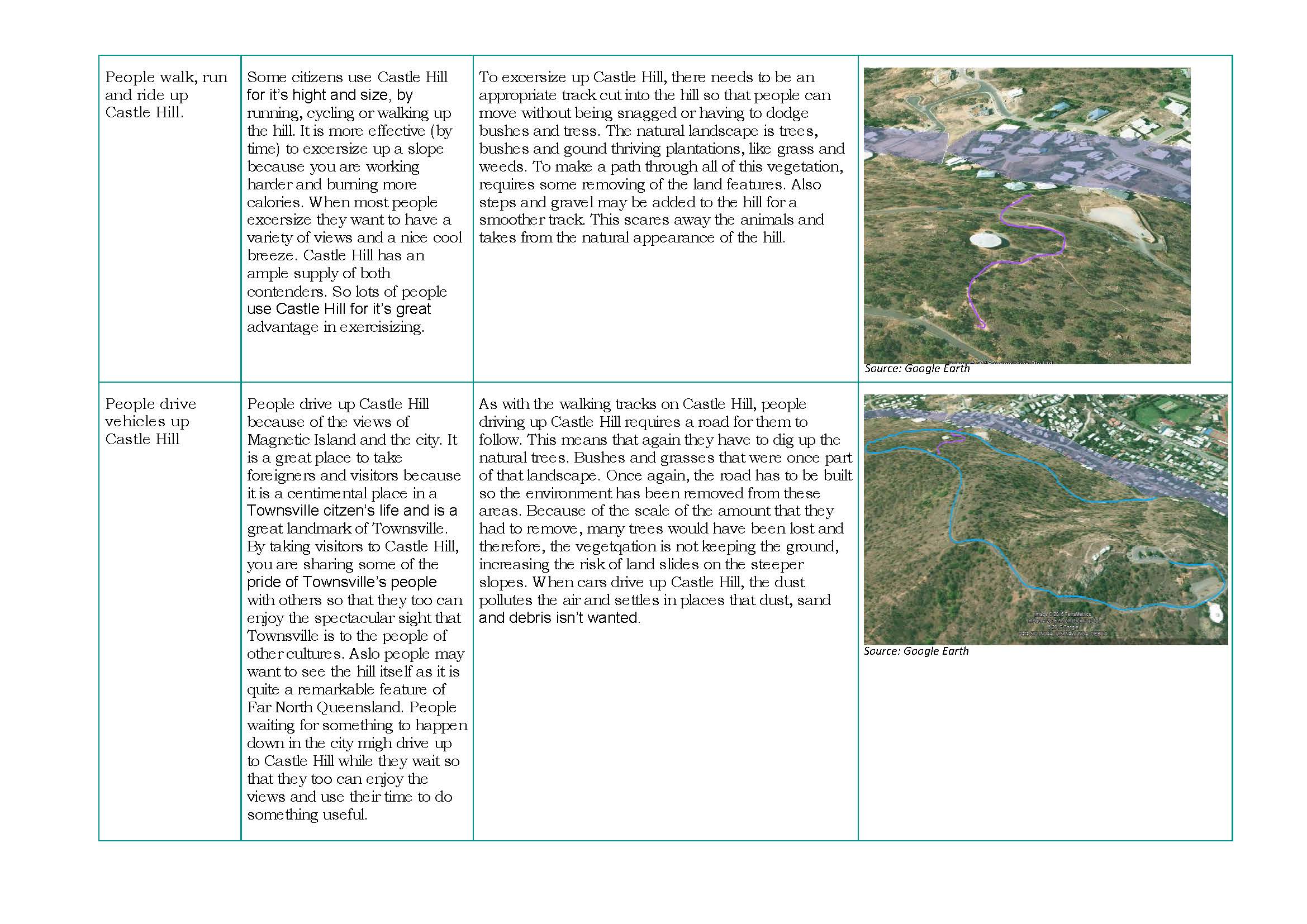 1
Annotation 1
Explains interconnections between people, places and environments 2 Annotation 2
Supports findings with annotated photographic evidence
-
Annotations
-
1
Annotation 1
Explains interconnections between people, places and environments -
2
Annotation 2
Supports findings with annotated photographic evidence
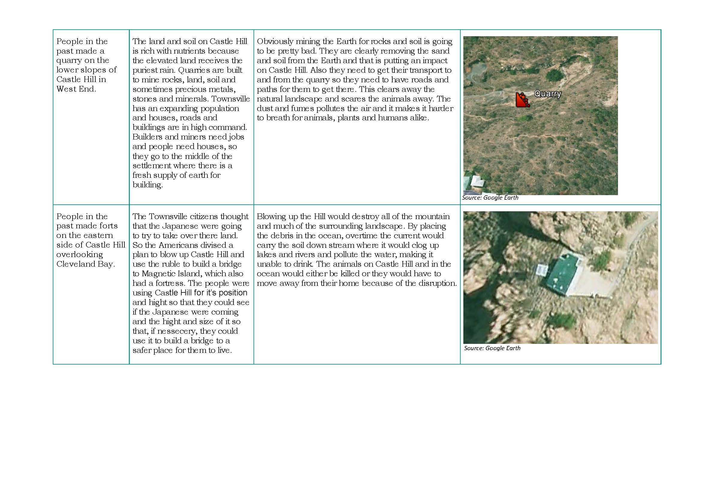 1
Annotation 1
Explains interconnections between people, places and environments 2 Annotation 2
Uses relevant geographical terminology
-
Annotations
-
1
Annotation 1
Explains interconnections between people, places and environments -
2
Annotation 2
Uses relevant geographical terminology
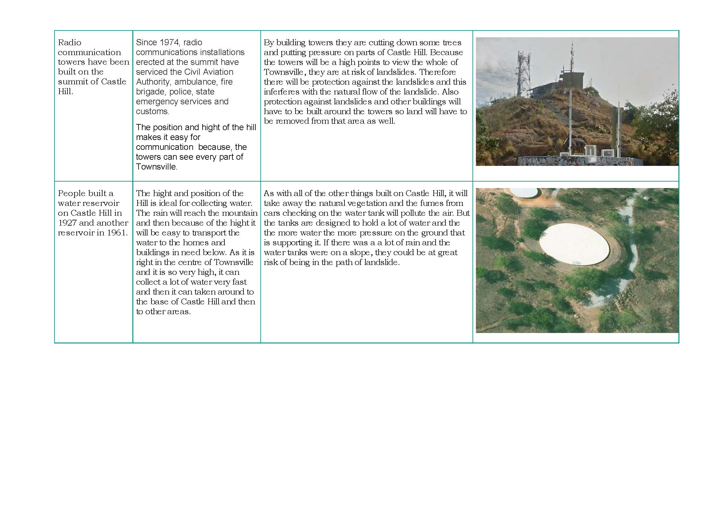 1
Annotation 1
Uses relevant geographical terminology 2 Annotation 2
Explains interconnections between people, places and environments
-
Annotations
-
1
Annotation 1
Uses relevant geographical terminology -
2
Annotation 2
Explains interconnections between people, places and environments
 1
Annotation 1
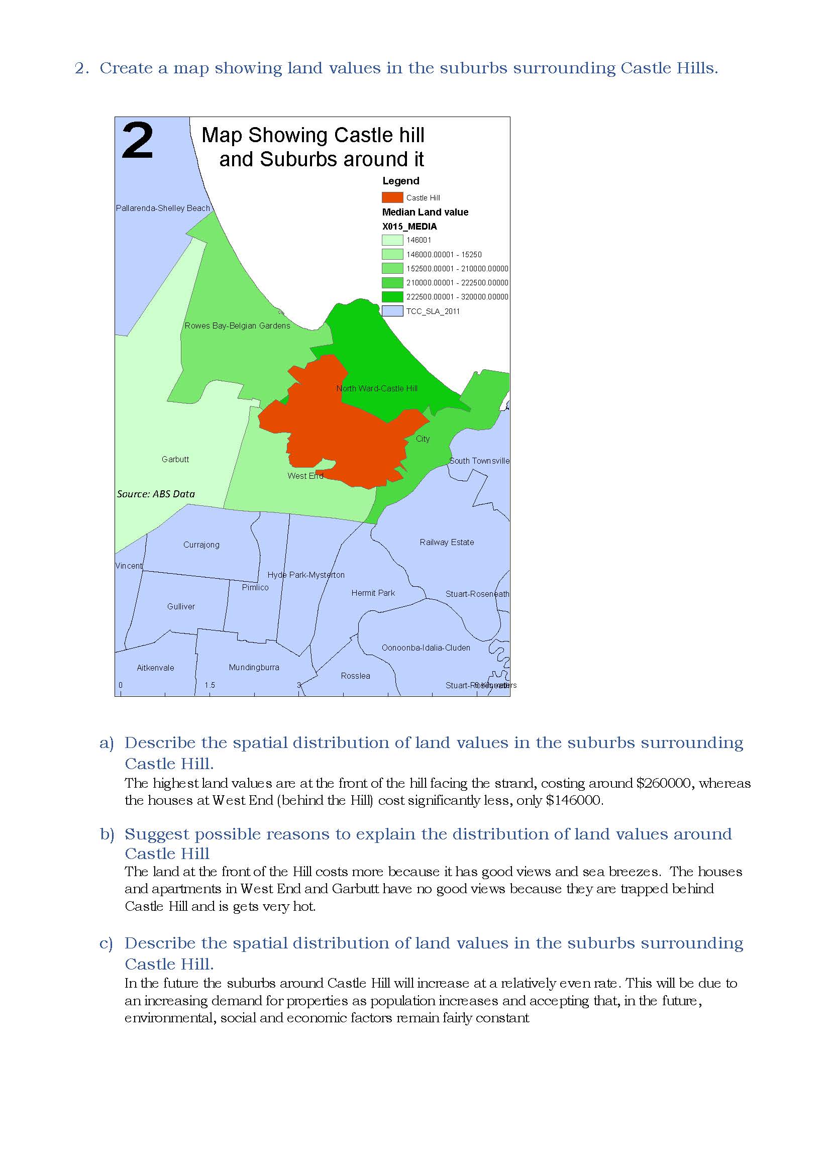
Uses a number of cartographic conventions 2 Annotation 2
Uses digital technologies to create a map showing land values 3 Annotation 3
Describes in simple terms the spatial distribution of land values based on the data in the map 4 Annotation 4
Provides an explanation for spatial distribution using geographical terminology 5 Annotation 5
Proposes changes to future land prices using geographical factors
-
Annotations
-
1
Annotation 1
Uses a number of cartographic conventions -
2
Annotation 2
Uses digital technologies to create a map showing land values -
3
Annotation 3
Describes in simple terms the spatial distribution of land values based on the data in the map -
4
Annotation 4
Provides an explanation for spatial distribution using geographical terminology -
5
Annotation 5
Proposes changes to future land prices using geographical factors
 1
Annotation 1
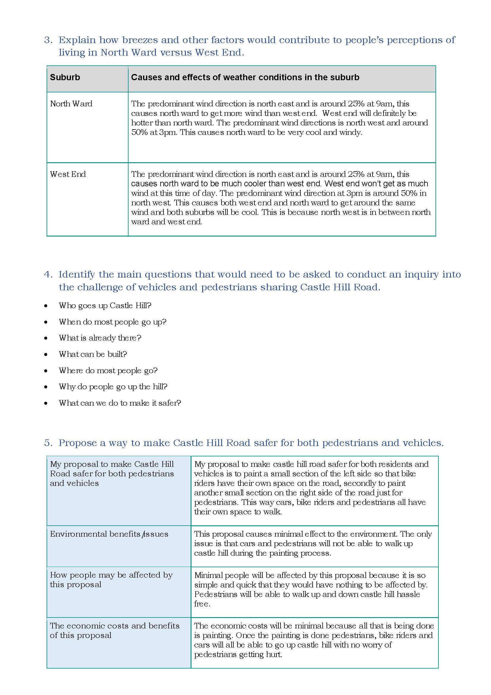
Provides an explanation of the effects of a geographical process on people’s perceptions of living in a place using data 2 Annotation 2
Proposes questions to frame a geographical inquiry 3 Annotation 3
Proposes a set of actions in response to a geographical challenge 4 Annotation 4
Presents predicted outcomes for each action
-
Annotations
-
1
Annotation 1
Provides an explanation of the effects of a geographical process on people’s perceptions of living in a place using data -
2
Annotation 2
Proposes questions to frame a geographical inquiry -
3
Annotation 3
Proposes a set of actions in response to a geographical challenge -
4
Annotation 4
Presents predicted outcomes for each action
 1
Annotation 1
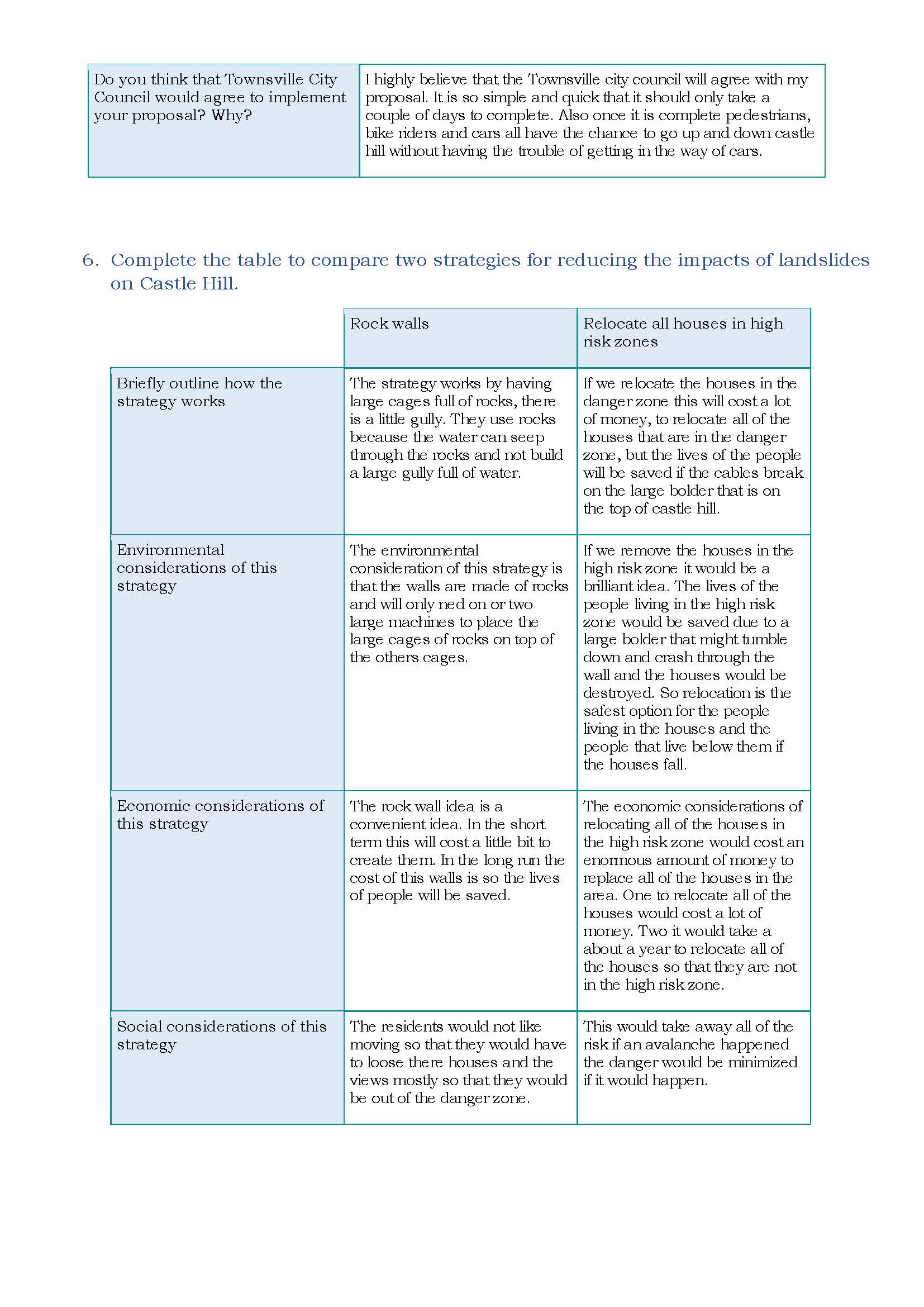
Presents predicted outcomes for each action 2 Annotation 2
Presents information describing the environmental, economic and social impacts of the two strategies
-
Annotations
-
1
Annotation 1
Presents predicted outcomes for each action -
2
Annotation 2
Presents information describing the environmental, economic and social impacts of the two strategies
Below satisfactory
Landforms and landscapes
 1
Annotation 1
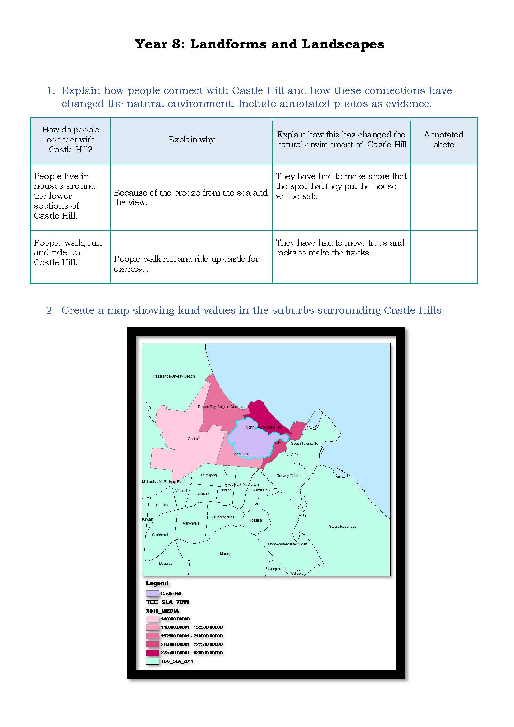
Uses simple geographical terminology 2 Annotation 2
Provides simple statements to describe interconnections between people, places and environments 3 Annotation 3
Presents simple findings in an appropriately formatted table 4 Annotation 4
Uses a few cartographic conventions 5 Annotation 5
Uses digital technologies to create a map showing land values
-
Annotations
-
1
Annotation 1
Uses simple geographical terminology -
2
Annotation 2
Provides simple statements to describe interconnections between people, places and environments -
3
Annotation 3
Presents simple findings in an appropriately formatted table -
4
Annotation 4
Uses a few cartographic conventions -
5
Annotation 5
Uses digital technologies to create a map showing land values
 1
Annotation 1
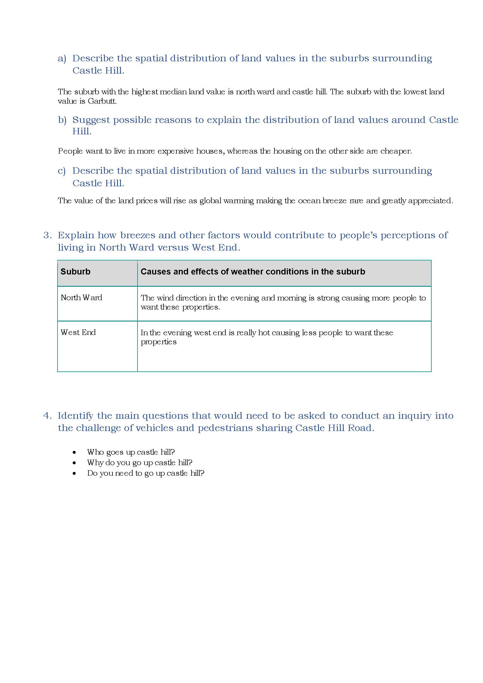
Identifies the highest and lowest median land value suburbs 2 Annotation 2
Gives a simple explanation for the spatial distribution 3 Annotation 3
Provides a simple proposition based on geographical information 4 Annotation 4
Gives a limited explanation of the effects of a geographical process on people’s perceptions of living in a place 5 Annotation 5
Proposes simple questions to frame a geographical inquiry
-
Annotations
-
1
Annotation 1
Identifies the highest and lowest median land value suburbs -
2
Annotation 2
Gives a simple explanation for the spatial distribution -
3
Annotation 3
Provides a simple proposition based on geographical information -
4
Annotation 4
Gives a limited explanation of the effects of a geographical process on people’s perceptions of living in a place -
5
Annotation 5
Proposes simple questions to frame a geographical inquiry
 1
Annotation 1
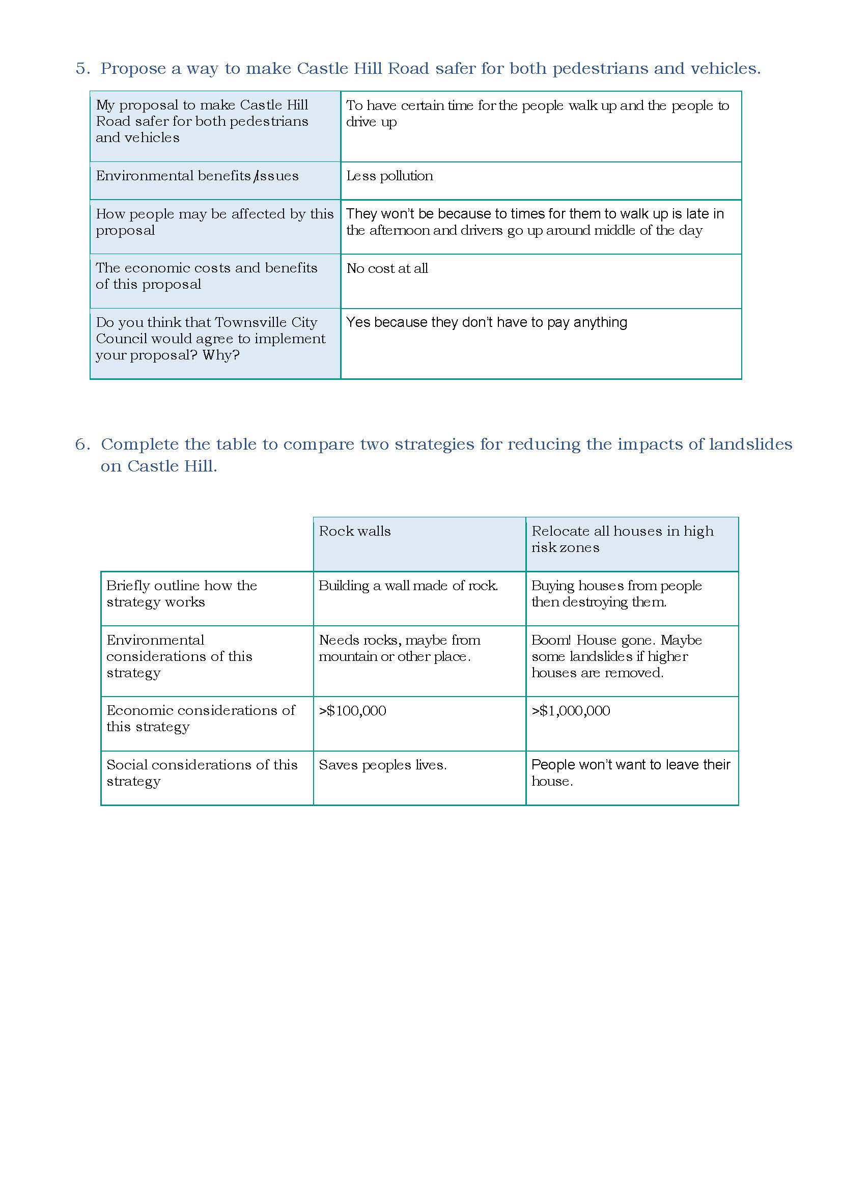
Proposes simple actions in response to a geographical challenge 2 Annotation 2
Presents simple predicted outcomes 3 Annotation 3
Presents information summarising the two strategies
-
Annotations
-
1
Annotation 1
Proposes simple actions in response to a geographical challenge -
2
Annotation 2
Presents simple predicted outcomes -
3
Annotation 3
Presents information summarising the two strategies
Above satisfactory
Landforms and landscapes
 1
Annotation 1
Presents detailed findings in an appropriately formatted table 2 Annotation 2
Explains in detail interconnections between people and places and within environments 3 Annotation 3
Uses relevant geographical terminology and technical vocabulary 4 Annotation 4
Supports findings with a variety of annotated photographic evidence containing specific annotations
-
Annotations
-
1
Annotation 1
Presents detailed findings in an appropriately formatted table -
2
Annotation 2
Explains in detail interconnections between people and places and within environments -
3
Annotation 3
Uses relevant geographical terminology and technical vocabulary -
4
Annotation 4
Supports findings with a variety of annotated photographic evidence containing specific annotations
 1
Annotation 1
Explains in detail interconnections between people and places and within environments 2 Annotation 2
Uses relevant geographical terminology and technical vocabulary 3 Annotation 3
Supports findings with a variety of annotated photographic evidence containing specific annotations
-
Annotations
-
1
Annotation 1
Explains in detail interconnections between people and places and within environments -
2
Annotation 2
Uses relevant geographical terminology and technical vocabulary -
3
Annotation 3
Supports findings with a variety of annotated photographic evidence containing specific annotations
 1
Annotation 1
Explains in detail interconnections between people and places and within environments 2 Annotation 2
Uses relevant geographical terminology and technical vocabulary 3 Annotation 3
Supports findings with a variety of annotated photographic evidence containing specific annotations
-
Annotations
-
1
Annotation 1
Explains in detail interconnections between people and places and within environments -
2
Annotation 2
Uses relevant geographical terminology and technical vocabulary -
3
Annotation 3
Supports findings with a variety of annotated photographic evidence containing specific annotations
 1
Annotation 1
Supports findings with photographic evidence
-
Annotations
-
1
Annotation 1
Supports findings with photographic evidence
 1
Annotation 1
Uses most cartographic conventions 2 Annotation 2
Uses digital technologies to create a map showing land values 3 Annotation 3
Describes in detail the spatial distribution of land values based on the data in the map 4 Annotation 4
Proposes explanations for spatial distributions, patterns and trends 5 Annotation 5
Proposes a detailed explanation for spatial distribution using specific geographical terminology 6 Annotation 6
Proposes changes to future land prices based on spatial distribution, trends and relationships
-
Annotations
-
1
Annotation 1
Uses most cartographic conventions -
2
Annotation 2
Uses digital technologies to create a map showing land values -
3
Annotation 3
Describes in detail the spatial distribution of land values based on the data in the map -
4
Annotation 4
Proposes explanations for spatial distributions, patterns and trends -
5
Annotation 5
Proposes a detailed explanation for spatial distribution using specific geographical terminology -
6
Annotation 6
Proposes changes to future land prices based on spatial distribution, trends and relationships
 1
Annotation 1
Gives a detailed explanation of the effects of a geographical process on people’s perceptions of living in a place, using data 2 Annotation 2
Proposes insightful, conceptual questions to frame a geographical inquiry 3 Annotation 3
Proposes a detailed set of actions in response to a geographical challenge
-
Annotations
-
1
Annotation 1
Gives a detailed explanation of the effects of a geographical process on people’s perceptions of living in a place, using data -
2
Annotation 2
Proposes insightful, conceptual questions to frame a geographical inquiry -
3
Annotation 3
Proposes a detailed set of actions in response to a geographical challenge
 1
Annotation 1
Presents detailed predicted outcomes for each action with supportive reasoning 2 Annotation 2
Uses geographical terminology
-
Annotations
-
1
Annotation 1
Presents detailed predicted outcomes for each action with supportive reasoning -
2
Annotation 2
Uses geographical terminology
 1
Annotation 1
Presents information and analyses the environmental, economic and social impacts of the two strategies, using examples 2 Annotation 2
Uses geographical terminology
-
Annotations
-
1
Annotation 1
Presents information and analyses the environmental, economic and social impacts of the two strategies, using examples -
2
Annotation 2
Uses geographical terminology