The Australian colonies
Summary of task
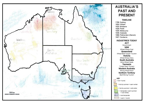
Students constructed climate maps to show the location of the major climate zones in Australia. Students then produced overlays for the maps to indicate key events from the colonial history of each state and territory along with indications of its main businesses. Students were provided with time and support in the school library and worked with a range of digital and print resources to collect their information. The maps were coloured and shaped by hand then scanned and uploaded into word-processing software for final labelling, publication and display in the classroom. The entire task was carried out in class over a three-week period.
Achievement standard
By the end of Year 5, students describe the significance of people and events/developments in bringing about change. They identify the causes and effects of change on particular communities and describe aspects of the past that have remained the same. They describe the experiences of different people in the past.
Students sequence information about events and the lives of individuals in chronological order using timelines. When researching, students develop questions for a historical inquiry. They identify a range of sources and locate, collect and organise information related to this inquiry. They analyse sources to determine their origin and purpose and to identify different viewpoints. Students develop, organise and present their texts, particularly narrative recounts and descriptions, using historical terms and concepts.
By the end of Year 5, students describe the location of selected countries in relative terms. They explain the characteristics of places in different locations at local to national scales. They identify and describe the interconnections between people and the human and environmental characteristics of places, and between components of environments. They identify the effects of these interconnections on the characteristics of places and environments. They identify and describe different possible responses to a geographical challenge.
Students develop appropriate geographical questions for an investigation. They locate, collect and organise data and information from a range of sources to answer inquiry questions. They represent data and the location of places and their characteristics in graphic forms, including large-scale and small-scale maps that use the cartographic conventions of border, scale, legend, title and north point. They describe the location of places and their characteristics using compass direction and distance. Students interpret maps, geographical data and other information to identify and describe spatial distributions, simple patterns and trends, and suggest conclusions. They present findings and ideas using geographical terminology in a range of communication forms. They propose action in response to a geographical challenge and identify the possible effects of their proposed action.

